![]() CEMETERIES OF SHELBY
COUNTY
CEMETERIES OF SHELBY
COUNTY
Go Back to Main
Page
| Cemetery | Township | |
| Antioch Find-a-Grave |
Taylor | From the records of the Shelby County Historical Society (apprx. 1971)...Located 1 mile north and 3/4 mile west of Leonard on Billie Lee Ballance Farm. Fenced but unkept, overgrown with trees and brush. Many stones down, unmarked graves, considered abandoned. |
| Allen Find-a-Grave |
Tiger Fork | From the records of the Shelby County Historical Society (apprx. 1971)…Located on R. Allen farm, northeast of house. Two (2) known graves. |
| Taylor | From the records of the Shelby County Historical Society (apprx. 1971)...Located 4 miles west and 1 1/2 miles north of Leonard, west of Salt River, west of road back in corner of field on Novinger Farm, and north of the Bill Schwanke (Funk) Farm. In early years known as the Allen Farm. Several graves reported here, farmed over and only pieces of monuments found, extinct. | |
| Bacon Chapel Find-a-Grave |
Lentner |
Bacon Chapel History From the records of the Shelby County Historical Society (apprx. 1971)...Located 3 miles north and 1 mile east of Lentner. Maintained and well kept. Fenced, large number of graves unmarked. Active church membership. |
| Baird Find-a-Grave |
Jackson | From the records of the Shelby County Historical Society (apprx. 1971)...Located 3 miles north of Hunnewell on Route Z. Extinct. |
| Baker | Jackson | From the records of the Shelby County Historical Society (apprx. 1971)...On Mrs. Raymond Day Farm 5 1/2 miles southeast of Shelbyville and is northeast of the house. |
| Baker-West | Black Creek | From the records of the Shelby County Historical Society (apprx. 1971)…Located 2 miles north of Shelbyville on Route 15 to P west 3 9/10 miles. North ½ mile or 1 mile northeast of Kirby on J.R. Weems Farm. Extinct. Information provided by Luther Turner and Mrs. George Miller, Shelbyville, MO. |
| Balliet | Nothing at this time. | |
| Baltzer Find-a-Grave |
Bethel | From the records of the Shelby County Historical Society (apprx. 1971)…On Hurley Harrison Farm. East and northeast of old Holdreath House, ¾ of a quarter, by big oak tree. No stones found. Extinct. |
| Bell | Tiger Fork | From the records of the Shelby County Historical Society (apprx. 1971)…Located south of old Bell home which still stands. Second house west of Doc Kinchelow. West of W. |
| Bethany
Methodist Find-a-Grave |
Black Creek | From the records of the Shelby County Historical Society (apprx. 1971)…At Bethany Church, M.E., ¼ mile N.E. of Shelbyville. |
| Bethel Chapel Find-a-Grave |
Tiger Fork | From the records of the Shelby County Historical Society (apprx. 1971)…1 ½ miles north of old Burksville store, on route W. No other description available. |
| Bethel Hebron Find-a-Grave |
Bethel | (a/k/a Old Colony Cemetery) – From the records of the Shelby County Historical Society (apprx. 1971)…One-half mile north, ½ mile west, ¼ mile north on the Clive Barrick Farm, from Bethel. |
| Bethel Zion Find-a-Grave |
Bethel | From the records of the Shelby County Historical Society (apprx. 1971)…One mile west of Bethel on blacktop road. |
| Blackford | Jackson | From the records of the Shelby County Historical Society (apprx. 1971)...On the Pat Dempsey place, extinct. |
| Blackburn Find-a-Grave |
Jackson | From the records of the Shelby County Historical Society (apprx. 1971)...On the Fred Walker Farm about 1 mile. East of Kendall and north. Extinct. |
| Boling | Lentner | From the records of the Shelby County Historical Society (apprx. 1971)...Located west of Lentner to State Road. Go south 2 miles then east 1 mile. Through gap in large hedge fence. Go north back in field around 3/8 mile. Follow fence line to small draw. At edge of field and northeast of large old barn, in trees and brush. Not maintained. Abandoned. |
| Bragg Find-a-Grave |
Tiger Fork | From the records of the Shelby County Historical Society (apprx. 1971)…Located on Highway J east of Bethel to J spur, then ½ mile east of J spur on Highway J. Bragg farm now owned by Marion Pugh. First burial place of Harry Latimer and John Holmes who died by firing squad in Braggs Orchard in 1862. Three other soldiers killed in action here the same day, Lear, Scanlon and Stevens. Later, Holmes and Latimer were moved to the Looney Cemetery. Scanlon, a Catholic, was moved later. Stevens and Lear are buried southwest of where Braggs are buried, on south side of road. Braggs are buried on the north side. |
| Brewington | Lentner | From the records of the Shelby County Historical Society (apprx. 1971)...Located 2 1/2 miles north of Lentner, 1 mile west and 1/2 quarter. On old Taylor place, extinct. |
| Browne (See also
Godfrey and Hunnewell IOOF) Find-a-Grave |
Jackson | From the records of the Shelby County Historical Society (apprx. 1971)...East part of the Hunnewell I.O.O.F., about 1 mile northeast of Hunnewell, north of Highway 36. |
| Buford | Tiger Fork | From the records of the Shelby County Historical Society (apprx. 1971)…Located a few yards south of old Buford home and west 150 yards. Now owned by Voncil Wood. |
| Cadwell Find-a-Grave |
Salt River | From the records of the Shelby County Historical Society (apprx. 1971)...Located 2 miles north and west of Shelbina on the old Cadwell Farm now owned by Gwynn O'Donnell, also 3/4 mile south of Walkersville Bridge. About 1/4 mile south and west of barn. Three (3) stones in large clump of cedar trees, abandoned. |
| Caldwell | Taylor | From the records of the Shelby County Historical Society (apprx. 1971)...Located 3/4 mile east and 1/4 mile south of Leonard on the Ralph Rogers Farm, in pasture. Sisters of Dr. Caldwell of Syrup and Pepsin fame who made medicine of herbs found on the farm. Two girls and one slave. Stones moved for preservation, extinct. |
| Calhoun Place | Tiger Fork | From the records of the Shelby County Historical Society (apprx. 1971)…Northeast of house 120 yards. Four stones: man, wife, and 2 sons. Wire fenced. |
| Calvert | Tiger Fork | A borderline cemetery in Marion county, Warren Township. Just over the Shelby county line. Researched by Mrs. Gerald Bonnel in 1971. |
| Carlisle | Tiger Fork | From the records of the Shelby County Historical Society (apprx. 1971)…Located east of Sigsbee on the bank of Fabius by home of Mrs. William Claus. Large oak tree marks spot. One grave. |
| Cedar Grove Find-a-Grave |
also known as King Cemetery | |
| Cherry Box Find-a-Grave |
Taylor | From the records of the Shelby County Historical Society (apprx. 1971)...Located 3/4 mile north of Cherry Box on east side of road. Stones erect, well kept, fenced. Some unmarked graves. |
| Chinn | Nothing at this time. | |
| Chinn-Hill-Hiles | Black Creek | From the records of the Shelby County Historical Society (apprx. 1971)…Located 2 miles west and south of Shelbyville on the Hiles Sisters Farm. Iron fence. Extinct. |
| Christian | Nothing at this time. | |
| Churchwell Children | Black Creek | From the records of the Shelby County Historical Society (apprx. 1971)…South and ¼ mile east of Bethany Church in an old orchard on William Easdale Farm. Extinct. |
| Clay | Lentner | From the records of the Shelby County Historical Society (apprx. 1971)...Rose Clay on Chinn Farm south and west of Lentner 3 to 4 miles. On east side of road and back in field about 300 yards. Stone against tree. |
| Coard-Duncan | ? | From the records of the Shelby County Historical Society (apprx. 1971)...In solid timber on the Claggett Farm. All west of the Simpson brick house about 1 1/2 miles. Very substantial iron fence. Brused in. Near high point and about 80 feet from bank of Salt River. |
| Cochrane Find-a-Grave |
Jackson | From the records of the Shelby County Historical Society (apprx. 1971)...On Albert Snider Farm, 4 miles north of Lakenan on east side of the blacktop road, about 250 yards in field with two trees as markers. One down, stone of William Cochrane who was born in Scottland. About 10 other people have been buried here. Extinct. Marker not in original place. (Jackson Township) |
| Concord Find-a-Grave |
Tiger Fork | From the records of the Shelby County Historical Society (apprx. 1971)…Located on J east of Beth 6 miles. Sign Sup. J. Turn left ¾ miles on state road. Many unmarked graves. |
| Crocket | Bethel | From the records of the Shelby County Historical Society (apprx. 1971)…Could not be located in course of this survey. It is presumed that the Crocket Family was together here, as this is where they lived. |
| Davidson-See | Jackson | From the records of the Shelby County Historical Society (apprx. 1971)...On the Everett Porter Farm. Second road west of the Hunnewell Lake Road. Go north 1/2 - 3/4 mile. Southwest of house about 1/2 mile in field and hog pasture, several downed stones. Extinct. |
| Deer | Jackson | From the records of the Shelby County Historical Society (apprx. 1971)...On the Myrl Snider Farm. First road east of Salt River Bridge east of Lakenan, go north around 3 miles, turn left and end up at dead-end road with gate. Old Deer House is 200 yards north of this gate. Only rocks and old lumber is left. The story, 2 soldiers died in St. Louis and were shipped back for burial. John Henry Snider was to meet the train to get the soldiers. They were buried at the Deer house or the house was built over the graves later. Soldiers died of a contagious disease and were shipped back in lead coffins. Right or wrong, we don't know. |
| Derringer | Nothing at this time. | |
| Dickerson | Salt River |
From the records of the Shelby County Historical Society (apprx. 1971)...On the George Campbell (Old Foley) Farm. First house north of Salt River Bridge (by 15) on west side of road. North of house about 1/4 mile in large clump of white oak trees, to the northwest corner of grove. Obidiah Dickerson is Shelby County's first settler. A historical marker locates the place of this first settler. Only river rock marks these graves. |
| Draughn | Salt River | From the records of the Shelby County Historical Society (apprx. 1971)...Location north and east of Shelbina. Go one (1) mile north of Salt River Bridge on Hwy. 15. Turn east and go to the end of road. In the northeast corner of 20 acres adjoining road. On the old John Draughn Farm now owned by Jess Jones. There were three (3) Draughn children buried here, two died of diphtheria, 1 died from eating green May apples (the story). Graves found by plowing through them. Complete extinct. |
| Dye-Borum Find-a-Grave |
Salt River | From the records of the Shelby County Historical Society (apprx. 1971)...Located on the Byron Peak Farm, approximately 2 miles north of farm in large clump of trees. Two miles west of Lakenan. Stones all down, brush, abandoned. |
| Eaton Find-a-Grave |
Salt River | From the records of the Shelby County Historical Society (apprx. 1971)...South of Carl Ridings Farm to first road going west, go 1/2 mile. On right side of road and back in field 100 yards. Fenced, two (2) large cedar trees and brush. Not maintained. NOTE: Nancy J. Eaton is buried 1/2 mile east of this cemetery on the old Hangar Farm. Description is in Jackson Township. |
| Eaton (Nancy) | Nothing at this time. | |
| Ebenezer Find-a-Grave |
Clay | From the records of the Shelby County Historical Society (apprx. 1971)...About 2 miles west of Hager's Grove, 1 mile north on K. Back one mile west on north side of road. Maintained, good condition, unmarked graves. |
| Eckle | From the records of the Shelby County Historical Society (apprx. 1971)...Pat and Hurley Dempsey Farm. Northeast of Lamar Portwood who lives on the Harvey Jordan Farm. (Jackson Township) | |
| Emden Baptist Find-a-Grave |
||
| Emden Memorial Gardens Find-a-Grave |
||
| Evans Family | Black Creek | From the records of the Shelby County Historical Society (apprx. 1971)…Located 2 ½ miles east of Shelbyville on William Collins’ place now owned by Charles Vannoy. An iron fence around 2 marked graves and one marked by a rock.. Another 3 graves just on outside of fence marked by rocks. Abandoned. |
| Fairview Find-a-Grave |
||
| First County Poor | Salt River | From the records of the Shelby County Historical Society (apprx. 1971)...Across the road from Lowman Chapel Church on the Eddie Renner Farm. There is Nothing at this time. left here, extinct, farmed over. |
| Foley-Moore | Black Creek | From the records of the Shelby County Historical Society (apprx. 1971)…On Route 15, 1 mile south of Bethel then east to end of road, then south ½ mile thru gate on the south side of road. Go southeast 1 mile. Once had a rock fence, but now most is gone. One marker remaining: Bushrod F. Moore, born June 13, 1835. Died May 7, 1845. |
| Forman, Capt. J. H. Family | Black Creek | From the records of the Shelby County Historical Society (apprx. 1971)…Located 1 mile north and 3 miles east of Shelbyville on Albert Snitger Farm, just north of the house. |
| Forman-Rookwood Find-a-Grave |
Black Creek | From the records of the Shelby County Historical Society (apprx. 1971)…East of Bethany Church. Buried in garden of E.F. Forman Farm. Grave unmarked. Farm now owned by T.W. Christine. Buildings and fences removed and being farmed over. Extinct. |
| Forest Grove Find-a-Grave |
Black Creek | From the records of the Shelby County Historical Society (apprx. 1971)…About 2 miles north of Shelbyville on route 15, to R. P. Thence west 3 ¾ miles or ¾ mile northeast of Kirby. North side of road and west of the Weems house. |
| Forsythe Carothers Find-a-Grave |
Salt River | From the records of the Shelby County Historical Society (apprx. 1971)...Located three (3) miles west, 1 1/2 miles north and back of the old Boss Searingen Farm. Go 1/2 mile north and west back into heavy timer. Iron fence, last grave about 1942. New grave marker set in 1965. Cecil Ratliff owns the farm now. |
| Franklin Family Find-a-Grave |
Jackson | From the records of the Shelby County Historical Society (apprx. 1971)...On the Guy Jordan Farm about 7 1/2 miles southeast of Shelbyville. Northwest of the barn. |
| Free Methodist | Nothing at this time. | |
| Gallagher | Tiger Fork | From the records of the Shelby County Historical Society (apprx. 1971)…On E.C. Calhoun place. Located north of Bethel, east on route M past Shiloh road, cross river and first house east. Inquire from here. R. L. Smoot is first house. Reported that these people killed by bushwackers during the Civil War. (a/k/a Calhoun) |
| Garnett Find-a-Grave |
Taylor | From the records of the Shelby County Historical Society (apprx. 1971)...Located 2 1/4 miles north and 3/4 mile east of Leonard across the road to east of William C. Caldwell home, formerly Orville Dodd Farm. Two hundred (200) yards east off road. Fenced, some lots maintained, others overgrown in weeds and brush. A number of unmarked graves. |
| Gentry | Bethel | From the records of the Shelby County Historical Society (apprx. 1971)…On the Bud Woods Farm. One-half mile east and ½ quarter south in field. Extinct. |
| Godfrey (See
also Hunnewell IOOF) Find-a-Grave |
Jackson | From the records of the Shelby County Historical Society (apprx. 1971)...West of Hunnewell 1 mile on old Highway 36. There are over 300 graves in this cemetery, including the unmarked graves. For its size it is the most poorly kept of any cemetery in Shelby County. We got no help from anyone in this town in running this cemetery. No one seems to be interested. Trees, brush, and prairie grass head high. The colored section on the south side has been kept up and the grass mowed. |
| Gilchrist Find-a-Grave |
Jackson | From the records of the Shelby County Historical Society (apprx. 1971)...On the Bob Corbin Dairy Farm northeast of Shelbina about 6 1/2 miles. Fenced, trees and brush, not maintained. W. E. Broughton noted in county history and his wife are buried here. Two flat stones, broken off at base and flat on ground. |
| Gill-Stalcup Find-a-Grave |
Clay | From the records of the Shelby County Historical Society (apprx. 1971)...Located 4 miles south of Clarence on 151, 2 7/8 miles east on gravel road, 3/4 miles north behind Ben Conrad's house on north fence line. House sets off 1/4 mile to north. Has been a number of graves here, extinct. |
| Gillis-Holliday Find-a-Grave |
Black Creek | From the records of the Shelby County Historical Society (apprx. 1971)…Located 1 mile east and 1 mile south of Shelbyville, on the Ed Wilcox Farm. Wire fenced. |
| Givans | Salt River | From the records of the Shelby County Historical Society (apprx. 1971)...Located 3 to 4 miles north and east of Shelbina on the Washburn Farm. Go through barnlot gate, north, follow road around curve east about 1/2 mile north side of road in trees and brush. Five (5) stones, all flat on ground. Extinct. |
| Glascock Find-a-Grave |
Tiger Fork | From the records of the Shelby County Historical Society (apprx. 1971)…Located on Elmer Douglas farm. Stones down, no fence, overgrown with brush and trees. Eight (8) Glascocks, 1 slave. |
| Goodwin Find-a-Grave |
||
| Goley | Taylor | From the records of the Shelby County Historical Society (apprx. 1971)...On the old Reuben McVey Farm now owned by Vernon Mann. Four to 5 miles northeast of Leonard, 1/2 mile quarter south and east of the barn, north side of branch and 25 yards east of well. Were 3 graves, in pasture, all markers and identification gone. Extinct. |
| Graves | ||
| Graves-Killenger | ||
| Grey | Taylor | From the records of the Shelby County Historical Society (apprx. 1971)...Located 3/4 mile east and 3/4 mile south of Leonard on bluff in farm pasture of Worthy Mahoney, present owner. On east side of road. Not fenced, unkept, a few stones standing, some unmarked graves, abandoned. |
| Greenfield Find-a-Grave |
Taylor | From the records of the Shelby County Historical Society (apprx. 1971)...Located 1 mile west and 1 mile north of Leonard, then 100 yards west of T intersection, north side of road. All graves marked, fenced and blue grass sod. Occasional care. |
| Grout | Salt River | From the records of the Shelby County Historical Society (apprx. 1971)...West of Lakenan to first road going north on the Jacobs Farm. North and east of house in field. Never any markers here. Relation of the Greenwells. No one furnished any information for this place. |
| Jackson | Early Family Cemetery - From the records of the Shelby County Historical Society (apprx. 1971)...Can be located in the Shelby County History of 1878. West 1/2 mile of S6-R9; Jackson Township, 160 acres owned by A. K. Grout. This farm bordered on the northwest corner of Lakenan and is west of the present highway. There were never any markers for these graves. They have been farmed over for years and they can be considered completely extinct. Other relatives have been buried in St. Mary's Cemetery at Shelbina. Also a stone marker with the names buried in the Old Grout Cemetery has been placed on the lot of George Josiah (Si.) Greenwell. | |
| Hagers
Grove Church Find-a-Grave |
Clay | From the records of the Shelby County Historical Society (apprx. 1971)...Maintained and in good shape. A number of down stones and unmarked graves. |
| Harland | Taylor | From the records of the Shelby County Historical Society (apprx. 1971)...On Raymond Gander Farm 2 1/2 miles west of Leonard, in field southwest of house. Exact location of grave is uncertain. A twin brother of Clifford Harland was buried here. Extinct. |
| Harvey | Lentner | From the records of the Shelby County Historical Society (apprx. 1971)...From Bacon Chapel corner, go west 1 1/2 miles, then 1/2 mile and 1/2 quarter north, across 5 acres to two cedar trees and an elm. Good fence of wire and iron posts set in cement. Another child of this family is buried at Bacon Chapel. Abandoned. |
| Hawkins Find-a-Grave |
Clay | From the records of the Shelby County Historical Society (apprx. 1971)...West of Ebenezzer 1 mile. Go south 1 mile, on the old Hawkins Farm now owned by Will Kemp. Near Macon County line. In brush, abandoned, extinct, 1 marker. |
| Hershey | Taylor | (Old Hershey) From the records of the Shelby County Historical Society (apprx. 1971)...In Cherry Box on Elwyn Jones farm. Directly across road east of the Harry Turner farm house, about 50 feet. |
| Hightower Find-a-Grave |
Salt River | From the records of the Shelby County Historical Society (apprx. 1971)...On Irwin Olbert first house on east side of road north of Salt River Bridge. Original cemetery was 1/2 mile east down timber road. Everything has disappeared. Only one stone found in front of a big hog house, used as a step. Extinct. |
| Jackson | From the records of the Shelby County Historical Society (apprx. 1971)...Located 4 miles north of Lakenan on Route T. West 1 mile, north of Hightower Schoolhouse 1 mile, 1/2 mile northwest through the field of Russell Willey Farm. Trees, brush, stones down. One Hightower here was born in 1776. | |
| Hilton Find-a-Grave |
Taylor | From the records of the Shelby County Historical Society (apprx. 1971)...Located 1 mile west and 1 mile south of Leonard, on the old T. P. Manuel Farm now owned by Geo. K. Keith. Five children from one family reported buried here. This place bulldozed out several years ago. Extinct. |
| Hope | Tiger Fork | From the records of the Shelby County Historical Society (apprx. 1971)…Located on farm owned by Gerald and Otho Bonnel, across road from Looney Creek church. |
| Hopper Find-a-Grave |
Clay | From the records of the Shelby County Historical Society (apprx. 1971)...Go west of Hager's Grove to Macon County Road. South on blacktop to first road going west. Go west 1/2 mile on north side of road, fenced, in tall grass and weeds. Not maintained, some unmarked graves. |
| Hoofer | Taylor | From the records of the Shelby County Historical Society (apprx. 1971)...Located 1 1/4 miles north and possibly 3/8 mile west of Cherry Box on Luther Turner Farm in pasture south of house. Exact location uncertain. Ulrey Hoofer and wife born and married in Switzerland moved to Shelby County in the 1850's and buried here. Extinct. |
| Howard | Black Creek | From the records of the Shelby County Historical Society (apprx. 1971)…On old Tonkinson place inherited by a daughter, Mrs. Clyde Green. Now owned by Dick Shively, 4 ½ miles east of Shelbyville on north side of road, blacktop #168. One grave: Mary Howard, girl around 12 years of age, no dates – one tombstone intact, several others buried there, but no markers. Information provided by Raymond Tonkinson, Emden, MO. (Black Creek Township). |
| Hughes-Sherwood | Black Creek | From the records of the Shelby County Historical Society (apprx. 1971)…Located 1 mile north and 3 miles west of Shelbyville, formerly Hughes and Gibson Farm, now owned by George Wilt. Plot is fenced off with pipe tubing. Field under cultivation. Tombstones under tree in field south of house. |
| Hunnewell IOOF (See
also Godfrey) Find-a-Grave |
Jackson | From the records of the Shelby County Historical Society (apprx. 1971)...Northeast 1 mile. The older part of the cemetery is east of the larger part. Maintained. |
| Hunolt-Forman | Taylor | From the records of the Shelby County Historical Society (apprx. 1971)...On Del Garner Farm, 1 3/4 miles south of Cherry Box and 3/8 mile east of house. Possibly an older generation of Hunolts and Formans buried here before 1865. |
| Indian Mounds | Salt River | From the records of the Shelby County Historical Society (apprx. 1971)...Located south of the house in the middle of a 40-acre field on Bill Hopkins place. Farmed over last 50 years. All traces of mounds are gone. Reported by Isa Quigley (deceased) from childhood memory. About 4 miles north and west of Shelbina. |
| Kaylor | Tiger Fork | From the records of the Shelby County Historical Society (apprx. 1971)…Located on Cecil Barrichter farm. Stones down, no fence, overgrown with brush. |
| Kendall Mt. Olive Find-a-Grave |
Jackson | From the records of the Shelby County Historical Society (apprx. 1971)...At Kendall, 3 miles north and 1 1/2 miles east of Lakenan. Nice cemetery, maintained. |
| Kidwell | Taylor | From the records of the Shelby County Historical Society (apprx. 1971)...On Joe Fifer Farm, north of house, 2 miles north and 1 mile west of Leonard. One infant grave of Mr. and Mrs. Garrett Kidwell. |
| ? | From the records of the Shelby County Historical Society (apprx. 1971)...Across the road from Oak Ridge Church on Joe Fifers Farm. Located 300 yards east of house on hill sloping east to bottom land. Grass and pasture now. Two large cedars near by. Extinct. | |
| Kinchelow | Tiger Fork | From the records of the Shelby County Historical Society (apprx. 1971)…On Thompson-Shores ranch. Wife and daughter of Reverend Jack Kinchelow. No dates. Extinct. |
| King (a/k/a Cedar Grove) Find-a-Grave |
Taylor | From the records of the Shelby County Historical Society (apprx. 1971)...Located 3 1/2 miles north and 1 1/4 miles west of Epworth. Fenced, stones in good shape, maintained and good records kept, but has not always been that way. A few unmarked graves. |
| Kurk | Tiger Fork | From the records of the Shelby County Historical Society (apprx. 1971)…On John Robert Kurk land. Southwest of Martin Lund home. Has been bulldozed out. |
| Kyle Find-a-Grave |
Clay | From the records of the Shelby County Historical Society (apprx. 1971)...Located 5 1/4 miles south of Clarence on 151, 1/2 mile east via private driveway and through field the last 1/4 mile is beyond the house. On the Callison farm. Abandoned. |
| Lair Find-a-Grave |
Tiger Fork | From the records of the Shelby County Historical Society (apprx. 1971)…East of Mt. Zion church. From Voncil Wood house go east ½ mile, north ½ mile. In a field east of the Claude Pope home. Located by a large cedar tree that can be seen from the Pope home. Iron fence, brush, many stones down. |
| Leonard Find-a-Grave |
Taylor | From the records of the Shelby County Historical Society (apprx. 1971)...North of Leonard Christian Church yard. Stone in good condition, fenced, well kept. A number of unmarked graves. |
| Lone House | Nothing at this time. | |
| Looney Find-a-Grave |
Tiger Fork | From the records of the Shelby County Historical Society (apprx. 1971)…On the Voncil Wood farm about ½ mile east of Mt. Zion Church. Located in a field a short distance south of Voncil Wood home. First house east of church. To date, the oldest stone in the county is here…1838. |
| Looney Creek (Old Brick) Find-a-Grave |
Tiger Fork | From the records of the Shelby County Historical Society (apprx. 1971)…Located ¾ mile east of old Burksville store. Take gravel road which goes to church. Well kept. Iron fence. |
| Lowery | Clay | From the records of the Shelby County Historical Society (apprx. 1971)...This place reported after the Cemetery Census Survey was completed. Map shows Lowery's lived on this farm in 1878. Four graves reported. Complete extinct. One mile north of Monroe county line and 1 mile west of Liberty School on Lawrence Harding Farm now. James and W. Lowery were the names at that time. |
| Lydick | Nothing at this time. | |
| Maddex | Nothing at this time. | |
| Maplewood Find-a-Grave |
Clay | (Clarence) From the records of the Shelby County Historical Society (apprx. 1971)...Kept in excellent condition. |
| Magruder Find-a-Grave |
Taylor | From the records of the Shelby County Historical Society (apprx. 1971)...Located 1 1/2 miles north and 3/4 mile west of Leonard, 1/2 mile south of the Joe Fifer home on east side of road. Not fenced, in pasture, overgrown, and stones down, abandoned. |
| Bethel | From the records of the Shelby County Historical Society (apprx. 1971)…On Lester Claggett Farm. East of Bethel on south side of road. The old Lewis Magruder place. One stone down, not fenced. Extinct. | |
| Masonic (Shelbyville) Find-a-Grave |
Black Creek | Shelbyville (Old) – West and north part of town. |
| Matkin | Bethel | From the records of the Shelby County Historical Society (apprx. 1971)…On the old Tom Staggs place now owned by Donald Shouse, ¼ mile north and ½ quarter west of house in field. One stone remaining on ground with 5 names of the Matkin family on it. Reported there were at least 30 graves here at one time. |
| Maud Christian Find-a-Grave |
Clay | From the records of the Shelby County Historical Society (apprx. 1971)...Located in Maud, south. Well kept. |
| McAfee | Taylor | From the records of the Shelby County Historical Society (apprx. 1971)...On Mrs. Mert Montgomery Farm, north from house in pasture, 1 3/4 miles south and 1 1/8 miles east of Leonard. Several graves, only one identified in pasture, unfenced, extinct. |
| McCully | Taylor | From the records of the Shelby County Historical Society (apprx. 1971)...Located on Virgil Vandiver Farm, 1/2 mile west and 1/4 mile south of Cherry Box, on hill about 75 yards, and north of the old William McCully Farm house. One stone monument and 7 graves with stone markers, abandoned. |
| McMurray | Black Creek | From the records of the Shelby County Historical Society (apprx. 1971)…Located ½ mile west and north of Kellerville store, on the Ed Vittetoe Farm. Northeast of the house on fence line. Extinct. |
| McWilliams | Taylor | From the records of the Shelby County Historical Society (apprx. 1971)...On Weldon Beach Farm 2 3/4 miles north and 1 mile west of Leonard, back from house east in pasture. Formerly home of Billy McWilliams family. Unfenced, several graves, none identified, markers gone, extinct. |
| Melson | From the records of the Shelby County Historical Society (apprx. 1971)...N.E. Clarence 3 to 4 miles, Howard Barr Farm. Rock at head and foot only marker. Ben Melson 1837. Information from Wess Wheeler. Other Melsons are buried in Clarence. | |
| Mennonite | Taylor | From the records of the Shelby County Historical Society (apprx. 1971)...Located 1 1/2 mile south of Cherry Box, just west of the Brethren Church. Stones in good shape, well kept, fenced. Some unmarked graves in old section. |
| Mesner Family | Black Creek | From the records of the Shelby County Historical Society (apprx. 1971)…Located 1 mile south of Bethel on Route 15, on Clint Mangold Farm, 1/8 mile off road on the east side and about 100 yards south of residence in garden. Two tombstones intact. |
| Miller | Lentner | From the records of the Shelby County Historical Society (apprx. 1971)...Located 1 mile east of Lentner and 1 mile north on the Bradford Todd Farm. Through gate and go 150 feet, near old cellar and large honey locust tree. Early settler bought this place and lived only a short time. Was buried here. Extinct. |
| Miller - Vanosdol Find-a-Grave |
||
| Million Family Find-a-Grave |
Clay | From the records of the Shelby County Historical Society (apprx. 1971)...Short distance south west of Maud and 1/16 mile north of the Ernest Shoemeyer corner. Abandoned and not maintained. |
| Morris Chapel Find-a-Grave |
Clay | From the records of the Shelby County Historical Society (apprx. 1971)...East of Hager's Grove, 3 miles and west of Kellerville 2 1/2 miles. On blacktop road. Maintained, very good shape, church is gone. |
| Mt. Hope Find-a-Grave |
Black Creek | From the records of the Shelby County Historical Society (apprx. 1971)…Located ¾ mile west of Kellerville store, then south 3 miles on gravel road. East side of road. |
| Mt. Zion Find-a-Grave |
Tiger Fork | From the records of the Shelby County Historical Society (apprx. 1971)…Located out of Shelbyville on 168 E to where Highway W goes north. Go past North River bridge to first road going west. Gravel road 2 ½ miles. Organized in 1834. Oldest in county. Well maintained. |
| Naylor | Bethel | On old Drake place now owned by Mersman (1970). North of house ¼ mile. Two names: father, son and wife. Extinct. |
| Nesbit | Tiger Fork | From the records of the Shelby County Historical Society (apprx. 1971)…Located on Culbertson farm, west of Buford house and south of Voncil Wood home. Iron fence. |
| New Providence Find-a-Grave |
From the records of the Shelby County Historical Society (apprx. 1971)...Located 3 1/4 miles west of Leonard at site of the old Cumberland Presbyterian Church. Gravel road back in field 1/2 mile. Fenced. Lot of downed stones due to livestock. Overgrown with prairie grass and brambles. Not maintained. | |
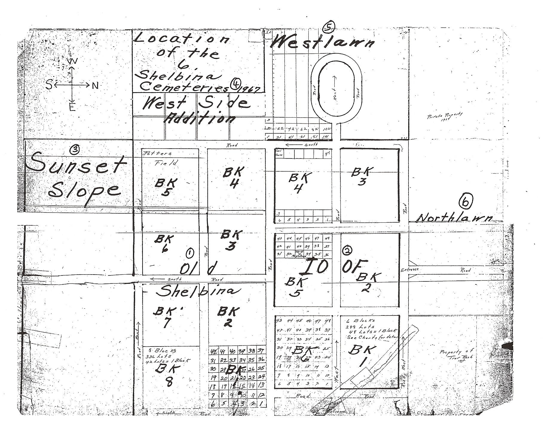
| Northlawn Find-a-Grave |
Salt River | See Shelbina IOOF Cemetery Cemetery Map |
| Oak Dale Find-a-Grave |
||
| Oak Ridge | Lentner | From the records of the Shelby County Historical Society (apprx. 1971)...South of Lentner about 6 miles. Cemetery at church which is still used. Fenced and well kept. Some graves unmarked. |
| Oakes | Bethel | From the records of the Shelby County Historical Society (apprx. 1971)…North of Epworth to crossroads 2 miles. One-quarter mile east of and ¼ mile north. Two hundred yards east in Cedar Grove. On Earl Quinley Farm. |
| Old City Find-a-Grave |
Clay | (Clarence) From the records of the Shelby County Historical Society (apprx. 1971)...Mowed once a year. Very poor. |
| Old Settlers | Tiger Fork | From the records of the Shelby County Historical Society (apprx. 1971)…On John Daugherty farm, no markers, little history. Reported very early settlers and timber cutters and one slave buried here. Extinct. |
| Otten | Tiger Fork | From the records of the Shelby County Historical Society (apprx. 1971)…Located on Robert Kurk land, 2 miles west of Concord, a few yards north of Otho Bonnel farm. Monuments hand hewn from stone by the late Jacob Otten, 1860. |
| Parker-Davis Find-a-Grave |
Jackson | From the records of the Shelby County Historical Society (apprx. 1971)...Located 1 1/2 miles east of the Lester Ridings Farm at the east end of Black Creek Bridge, then south about 40 yards. In large timber. Close to stream and some graves have been washed out. Two stones, one standing other down. Must have been dozens of people buried here as the graves have been marked with river rocks. Complete abandoned. |
| Parker-Wright | Nothing at this time. | |
| Parish | Lentner | From the records of the Shelby County Historical Society (apprx. 1971)...From Bacon Chapel corner, go west 3/4 mile, 3/4 mile north. Stone not in original place but at the house on the Harry Butner Farm. Extinct. |
| Parsons Find-a-Grave |
Tiger Fork | From the records of the Shelby County Historical Society (apprx. 1971)…North of Perry Parsons’ home, on north bank of river above North River Bridge. Slaves buried here. |
|
Patton Find-a-Grave |
Is it Clay or Bethel? | From the records of the Shelby County Historical Society (apprx. 1971)...Located 1 1/4 miles east, 1 mile south, 1/4 mile west of Hager's Grove. On north side of road. Graveled driveway into brush and trees. Just east of the Bill Jones Farm now owned by Frank Mason. Abandoned. (Clay Township) |
| From the records of the Shelby County Historical Society (apprx. 1971)…East of Hager’s Grove 1 ¼ miles to cross road. South one mile, west ¼ mile to gravel crossing on north side of road, iron gate. Through iron gate, 150 yards. (Bethel Township). Cemetery takes its name from Captain S.S. Patton, a Civil War veteran, born in Ireland, died at age 56 years on August 3, 1888. Taken from 1911 History of Shelby County, Mo., page 1074. | ||
| Payne-Jones Find-a-Grave |
Black Creek | From the records of the Shelby County Historical Society (apprx. 1971)…About 5 miles northeast of Shelbyville to the Clifford Taylor place in a bluegrass pasture on a high ridge. Only one tombstone with an inscription, Eliza Jones, Oct. 2, 1865, age 42 years. Limestone rocks mark mounds for 10 graves. |
| Peak-Miller | Nothing at this time. | |
| Pence | Jackson | From the records of the Shelby County Historical Society (apprx. 1971)...In 1878 J. L. Pence owned this 80 acres west of the adjoining Oak Dale Grange Park today. House was situated in the northwest corner of the farm. The cemetery located is southeast of the house several hundred yards and south side of spur road that goes to the house. About the middle of a hill sloping east which used to be in brush and trees. This has all been cleared out (1966). Perry Oak (in his 80's) farmed this ground and was asked by a Mrs. Snider not to farm over the graves as they were some of her relatives and ancestors. Evidently J. L. Pence, his wife, and others are buried here. This is all we can find to date. Completely extinct, no markers or rocks. |
| Peoples Find-a-Grave |
Taylor | From the records of the Shelby County Historical Society (apprx. 1971)...Located 1 mile south and 3/4 mile east of Leonard, across road to south of Ted Brown's house. Fenced, stones erect, well kept and good records, including a plt of cemetery. Endowed. |
| Perry Find-a-Grave |
Taylor | From the records of the Shelby County Historical Society (apprx. 1971)...Located 2 miles west and 3/8 mile north of Leonard. Northwest of house several hundred yards on the old Cul Perry estate. In pasture east of branch. Fenced but unkempt. Overgrown with brush and trees. Some stones down. Last burial here in October 1966. A Perry woman. |
| Perry Slaves | ||
| Pickett Find-a-Grave |
Bethel | From the records of the Shelby County Historical Society (apprx. 1971)…On Aaron Mesmer Farm, ½ mile east of Bethel, second house on north side of road. |
| Pleasant Prairie Find-a-Grave |
Bethel | From the records of the Shelby County Historical Society (apprx. 1971)…Northwest of Bethel about 4 miles, on blacktop road. Ten west ¼ mile on gravel. At church, on south side of road. |
| Pleasant View Find-a-Grave |
Tiger Fork | From the records of the Shelby County Historical Society (apprx. 1971)…church organized in 1839. Located west of Frank Glascock farm about ½ mile on south side of road. Oldest stone is 1839. No church now. NW ¼ of Section 25. |
| Prairie View Find-a-Grave |
Jackson | From the records of the Shelby County Historical Society (apprx. 1971)...Prairie View is 6 miles northwest of Hunnewell. Church and cemetery together. |
| Preston Find-a-Grave |
Tiger Fork | From the records of the Shelby County Historical Society (apprx. 1971)…Old C.E. Preston farm now owned by Willard Preston. Northeast of Pugh farm. Large oak tree marks place. |
| Priest Family Find-a-Grave |
Black Creek | From the records of the Shelby County Historical Society (apprx. 1971)…Located on the old Priest Farm, the Louis Nefschafer Farm and now owned by Olen Steifel. About 5 miles west of Shelbyville and 1 ½ miles south and east of Kellerville. Extinct. |
| Reynolds Family Find-a-Grave |
Clay | From the records of the Shelby County Historical Society (apprx. 1971)...Located 7 miles south of Clarence on Rt. 151. Two miles west on Route Y, to Macon County line, 1/4 mile south on neglected road, line road, 3/8 mile east through field to hilltop. On farm owned by the older Reynolds in 1878. Extinct. |
| Robb Family Find-a-Grave |
Nothing at this time. | |
| Robbins Find-a-Grave |
Jackson | From the records of the Shelby County Historical Society (apprx. 1971)...On Keith Mayes Farm, Route T, 5 miles north of Lakenan and 2 1/2 miles north of Kendall. Abandoned. |
| Roff Find-a-Grave |
From the records of the Shelby County Historical Society (apprx. 1971)…Located 4 ½ miles northwest of Shelbina | |
| Rookwood Family Find-a-Grave |
Black Creek | From the records of the Shelby County Historical Society (apprx. 1971)…Located 2 miles north of Shelbyville on Route 15 to Route T.P., west several hundred yards then off road south ¼ mile in field, under a large cedar tree. Three flat stones lean againt tree. Hiram Rookwood, wife, and son are buried here. |
| Rufener | Lentner | From the records of the Shelby County Historical Society (apprx. 1971)...On old Chinn place, now Bowman Farm. One mile north of Lentner and 2 miles west in barn lot. Extinct. |
| Rust Find-a-Grave |
Tiger Fork | From the records of the Shelby County Historical Society (apprx. 1971)…Located east of Bethel 3 miles, on J off road in brush. Four (4) stones remaining, almost extinct. |
| Rutter | Tiger Fork | From the records of the Shelby County Historical Society (apprx. 1971)…Located on farm owned by Gerald and Otho Bonnel, near S.P. Jones home on Highway J. Slaves and unmarked graves also. |
| Saunders Find-a-Grave |
Nothing at this time. | |
| Sayre | Black Creek | From the records of the Shelby County Historical Society (apprx. 1971)…Located ½ mile east and north of Henry Claussen residence on the Claussen Farm on Route 68 east of Shelbyville. Only broken stone with inscription left, but others believed to be buried here. Sayre, wife of Rev. Ezra Sayre, died January 31, 1865, Age 63 years, 1 mo., 16 days. |
| Shelbina Catholic Find-a-Grave |
Salt River | Located in southeast corner of city limits of Shelbina. |
| Shelbina (Old) Find-a-Grave |
Salt River | Cemetery Map Go HERE for Excel spreadsheet containing all known info (through July 2016) on burials in this cemetery. |
| Shelbina IOOF Find-a-Grave |
Salt River | Cemetery Map |
| Shelbina Mausoleum 1 Find-a-Grave |
Salt River | Located outside the gates of Shelbina IOOF |
| Shelbina Mausoleum 2 Find-a-Grave |
Salt River | Located outside the gates of Shelbina IOOF |
| Shelbyville
Old Find-a-Grave |
Black Creek | Shelbyville - Located in the southwest corner of the newer part of Shelbyville IOOF (a/k/a Shelby Memorial) |
| Shelbyville IOOF
(name changed to Shelby Memorial) Find-a-Grave |
Black Creek | Shelbyville – Located in the southwest part of town. |
| Shelbyville Masonic Find-a-Grave |
||
| Shelbyville Mausoleum Find-a-Grave |
Located on the northwest corner of Shelby Memorial Cemetery (Shelbyville IOOF) | |
| Sherry Find-a-Grave |
Nothing at this time. | |
| Shiloh Find-a-Grave |
Bethel | From the records of the Shelby County Historical Society (apprx. 1971)…North of the church ½ mile. Off road east and north on Clifford Marquette place. Three stones down, no fence. |
| Bethel | From the records of the Shelby County Historical Society (apprx. 1971)…North and east of Bethel about 4 miles, on blacktop road. Go north from Grover Smoot corner. Chart on west wall of Church shows plat of cemetery with names. | |
| Shores Find-aGrave |
Taylor | From the records of the Shelby County Historical Society (apprx. 1971)...Located 1 3/4 miles north and 1 1/2 miles west of Cherry Box in pasture some distance north on road on W. L. Heakson Farm. Fence down except around one family lot. Unkempt, overgrown with brush and trees. A number of unmarked graves. |
| Short | Bethel | From the records of the Shelby County Historical Society (apprx. 1971)…West of Bethel 2 miles on old Bonnell Farm. North of Dave Schnaufer House ¼ mile. One-half quarter west, back in pasture. Three stones standing, fence. (Abandoned) |
| Shride | Nothing at this time. | |
| Simmons | Nothing at this time. | |
| Singleton | Taylor | From the records of the Shelby County Historical Society (apprx. 1971)...On site of the old North River Church, now gone - 1 1/2 miles east and 2 1/4 miles north of Leonard. On Howerton Farm now. Three Singletons are buried here, unfenced, in brush and trees, stones flat on ground, extinct. |
| Smith-Barker Find-a-Grave |
? | From the records of the Shelby County Historical Society (apprx. 1971)…Located 2 miles north and west of Shelbina to crossroads, turn west 200 yards then 150 yards north in field to large clump of trees. On the Milton Wood farm. Abandoned. |
| Smith-Morris | Salt River | From the records of the Shelby County Historical Society (apprx. 1971)...Located 3/4 mile north of Walkerville Bridge on Vincil Keith Farm. East side of road about 300 yards. Brush, large trees, abandoned. Stones all down and piled against tree. |
| Snider-Moss | Jackson | From the records of the Shelby County Historical Society (apprx. 1971)...S28-R9-T57. Is located on the Lippincott Farm (1971) -- which has been sold lately (1972) about 1 mile south of Kendall and about 1/2 mile east of the barn, on the east side of the road, in brush. Only a gas pipe marker for John Henry. No other markers for the people buried here were found. A large number of Walter Moss' slaves reported to be buried here. John Henry Snider met a train at Hunnewell bearing the coffins of two soldiers by the name of Deer. They died in St. Louis of some epidemic and were shipped here in lead coffins. The train was late and probably no depot at that time and the exposure caused John Henry to take pneumonia and he died within three days after meeting the train. This is the current story that goes with this cemetery. NOTE: We have tried unsuccessfully to locate these lead caskets with a metal detector on the Deer place, but (1971) have had no luck. |
| Snowder Find-a-Grave |
Is it Clay or Bethel? | From the records of the Shelby County Historical Society (apprx. 1971)...Start at Snowder's Bridge, go south, road to first house, south 200 yards more or less, west side of road, back in brush and trees from 75 to 100 yards, follow hog (sic) back or high point of land. On Ches Adams Farm. Abandoned, extinct. (Clay Township) |
| From the records of the Shelby County Historical Society (apprx. 1971)…Start at Snowder’s Bridge, south around bend of road past Ransdall Farm and approximately 200 yards south. Located in west side of road about 100 yards in brush on “hog back” high ground. (Bethel Township). | ||
| St. John's Find-a-Grave |
Jackson | (a/k/a Hunnewell Catholic) From the records of the Shelby County Historical Society (apprx. 1971)...One mile southwest of Hunnewell near county line. |
| St. Mary's Find-a-Grave |
Cemetery Map | |
|
St. Michael's Find-a-Grave |
Clay or Bethel? |
From the records of the Shelby County Historical Society (apprx. 1971)...Located 1 1/4 miles east and 1 1/2 miles north of Hager's Grove. Excellent condition. (Clay Township) |
| (Hager’s Grove) – From the records of the Shelby County Historical Society (apprx. 1971)…Located 1 ¼ miles east and 1 ½ miles north of Hager’s Grove. Data taken by Rev. William Ludwig, pastor of St. Patrick’s Catholic Church, MO. (Bethel Township). | ||
|
St. Patrick's Find-a-Grave |
Clay | From the records of the Shelby County Historical Society (apprx. 1971)...Southwest part of town. Very good shape. (Clay Township) |
| From the records of the Shelby County Historical Society (apprx. 1971)...Located in southwest part of town. (Bethel Township) | ||
| Stauffer Find-a-Grave |
Bethel | From the records of the Shelby County Historical Society (apprx. 1971)…On Gertie Lair Farm, south of house about ¼ mile on east bank of North River in a locust grove. One stone intact. |
| Sunset Slope Find-a-Grave |
Salt River | See... Shelbina IOOF Cemetery Cemetery Map |
| Taylor Family Find-a-Grave |
Lentner | From the records of the Shelby County Historical Society (apprx. 1971)...Major Taylor and wife on Karl Thurman Farm. North of Floyd Moore place. North and west of Lentner 3 or 4 miles. One stone, down in brush and trees. Extinct. |
| Thomas | Nothing at this time. | |
| Thoroughman | Bethel | From the records of the Shelby County Historical Society (apprx. 1971)…Start at the Grover Smoot corner 4 miles northeast of Bethel. Go east 1 ¼ mile. Turn north 2 miles, east ½ mile to old Thoroughman Farm, now owned by Harry Van Skike. Abandoned. |
| Union Chapel Find-a-Grave |
Jackson | |
| Union Grove Find-a-Grave |
Clay | From the records of the Shelby County Historical Society (apprx. 1971)...South of Clarence about 6 miles on Rt. 151. Old cemetery is back of church on west side of road. New cemetery is on east side of road. Very well kept and endowed. |
| Utz Find-a-Grave |
Jackson | From the records of the Shelby County Historical Society (apprx. 1971)...On Hugh Snider Farm, about 1/4 mile east of the Kendall Schoolhouse, on north side of road, back in field about 300 yards. Trees, brush, abandoned. |
| VanDeren Find-a-Grave |
Black Creek | From the records of the Shelby County Historical Society (apprx. 1971)…Located 1 mile south of Kirby or 7 ½ miles north and west of Shelbyville on the Fred Christoffer Sr. Farm. About ¼ mile of a quarter over in the field on the east side of road on 40 acres of land referred to as “Old Barney” years ago. Only tombstone left is Sarah M. Baker and 5 mo. Old daughter leaning against tree, and 4 cement corner posts which have fallen over. Extinct. |
| Vandiver Family Find-a-Grave |
Taylor | From the records of the Shelby County Historical Society (apprx. 1971)...Located 3/4 mile west and 1/2 mile north of Cherry Box in deep woods on the Wayne Killen farm, formerly the Jim Shores Woods. Nine (9) graves identified but was originally 12 to 15. Practically lost in underbrush and trees. Stones gone except a few native stone markers. |
| Black Creek | From the records of the Shelby County Historical Society (apprx. 1971)…Located 1 mile south of Bethel, then west 1 ½ miles, turn south ¼ mile to house in field on the H.L. Trenhaile Farm. East of the house in chicken yard near henhouse. See Shelby County History for this historical record to the county. | |
| VanHouten | Clay | From the records of the Shelby County Historical Society (apprx. 1971)...Three (3) graves back of Frank VanHouten's house about 1/2 mile south and east of house. Children of Isaac and Louise VanHouten. Extinct, no markers and grown up in brush. |
| VanOsdol-Miller Find-a-Grave |
Bethel | From the records of the Shelby County Historical Society (apprx. 1971)…Five miles north of Bethel to the Ross Jones Farm. Then ¾ mile west. Then north in field. Extinct. |
| Varner-Watkins | Nothing at this time. | |
| Weeden | Tiger Fork | From the records of the Shelby County Historical Society (apprx. 1971)…Charlie Weedon, Civil War veteran. Site of early post office, Pansey, Mo. Also blacksmith shop and country store, in 1884. Shop run by Ruckman. |
| Wesley Chapel | Clay | From the records of the Shelby County Historical Society (apprx. 1971)...Located 2 miles north of Clarence and 3/4 mile east on the old L.F. Carothers place, in 1878 and later known as the Lon Wheeler Farm and now owned by Chester Crawford. This place was located on the map of 1878, after the cemetery survey was completed. No one seems to know anything about this place, although the map specifically designates that the cemetery was here. Wesley Chapel was here before the 1900s and according to the deed on the Crawford Farm, the cemetery was moved to Clarence. Records from the Clarence cemetery offer no information. Bertha Hopper (now in her 80s- 1966) remembers attending this chapel. No idea as to who was buried here has been found. I have checked about everything to get this information. This was in 1966. |
| West Lawn (a part of the Shelbina Cemeteries) | Salt River | See Shelbina IOOF Cemetery Cemetery Map |
| Woods | Salt River | From the records of the Shelby County Historical Society (apprx. 1971)...Located 4 1/2 miles northwest of Shelbina on the Milton Wood Farm, 1/4 mile back in timber on gravel road. Well kept and full maintained, fenced. |
| Worthington | Nothing at this time. | |
| Zion Hills | Tiger Fork | From the records of the Shelby County Historical Society (apprx. 1971)…Located just before you get to Bethel Chapel. Church gone, many unmarked graves. |
For Unknown Graves, Unnamed Cemeteries, and Some Slave Graves, go here.
Go Back Main Page